| Page 2 | Plaza Park Menu |
|
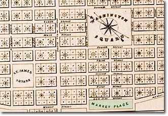
Green shaded area labeled "Market Place" in the illustration is now called Plaza de Cesar E. Chavez. This park has had many names: Prior to 1848 - The
Plaza, Market Square The map was drawn by the redoubtable Chester S. Lyman in 1848 - just in time for San Jose's reign as state capital in 1849. Note that The Plaza is actually "squarish." In later years this evolved into an ellipse - its present shape. The rounding off of the southern end of The Plaza occurred with the construction of the Civic Auditorium in 1934. |
| Page 2 | Plaza Park Menu |